My current perspective
A happy hello to you. My name is Kim Shortreed (he/him), and I am an uninvited guest in lək̓ʷəŋən and W̱SÁNEĆ territories in the Salish Sea. I am a recent (May, 2023) PhD graduate and an artist.
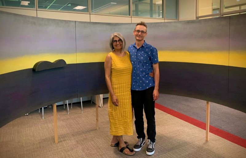 Standing inside the Untitled ṮEṮÁĆES map with Jillian [L].
My academic work is interdisciplinary: I focus on place names, or toponyms, through a particular lens, drawing from a mix of geohumanities, cartography, history, media studies, digital humanities, Indigenous studies, and settler colonial studies. I am interested in the settler-politics and social-justice aspects of “namescapes,” what I understand as the way we make and maintain a sense of place through naming landscapes. You can learn more about my academic and professional background on my CV webpage.
I recognize that it is important to provide this personal context so that you can understand a little more about what motivates my work, which is all part of a lifelong journey to connect with, learn about, and honour the landscapes and seascapes around me that I love so much.
I was born on the west coast of England in a beach town called Weston-super-Mare. Maternally my family has roots in England, Australia, and India.
Click here to read the rest of this post...
 |
| Where I grew up, in Semiahmoo Territory, near the Canada/USA border. |
When I was five, we emigrated to Treaty 6 territory (Edmonton) next to the North Saskatchewan River, or kisiskâciwanisîpiy, in Cree, where my stepdad was born and raised. We then moved to White Rock, what I consider my home town, in Semiahmoo (SEMYOME) Territory. I grew up playing on the beach as an uninvited guest within and around the boundaries of the Semiahmoo Reserve. My childhood soundscape was seagull cries, surf, and passing trains, and my scentscape was dusty rosehip bushes, sunbaked kelp, steaming tidal pools, and train-track creosote, and that particular wet-bone tang of decayed sand dollars.
To this day I could not imagine living away from the sea. I spent countless hours staring across Semiahmoo Bay to W̱SÁNEĆ territory, or the Gulf Islands and Vancouver Island, in the distance. At the time, like most W̱ENITEM, or White, Anglo settlers, I knew nearly nothing about the Indigenous histories and ongoing presences on SEMYOME or W̱SÁNEĆ lands, despite the fact that when we were all kids, my brother Jode and I used to hang out and mostly skateboard with Charlie Xwopokton Chappell, who became SEMYOME Chief in late 2016. It feels surreal that Charlie would go on to be Chief. It is also telling of the settler education system's shortcomings: I grew up playing on and next to the Semiahmoo Reserve, yet I was taught very little about the Indigenous cultures and Peoples around me.
 | Looking south from TATLU (Campbell River), in Semiahmoo Territory. |
The older I get the more grateful I am for my time in SEMYOME territory. About 25 years ago I moved to lək̓ʷəŋən Territory (Victoria) and I have explored this region by land and sea ever since, along with Jillian, whom I’ve been with for over 20 years. Her family has welcomed me with open hearts. I am grateful to have written these words on unceded W̱SÁNEĆ and lək̓ʷəŋən lands.
As part of my PhD dissertation project, artist TEMOSEṈ and I are prototyping the first iteration of a “haptic map” concept, the Untitled ṮEṮÁĆES map (which this blog is about): a motion-activated art installation that plays audio clips of spoken toponyms in SENĆOŦEN and English. This installation portrays an artistic representation of a W̱SÁNEĆ territory seascape but without signs, cardinal directions, borders, or the usual elements found on Western-style maps. You walk into a wraparound map space of what looks like a seascape with a distance horizon.
When inside the map, you will hear sounds that you might experience on a Salish Sea shoreline, such as seagull cries, lapping waves, and wind. Three-dimensional objects, intended to represent silhouettes of islands, sit along an ocean horizon. Each island contains a motion-detecting sensor and a speaker. Moving an island activates an audio voice recording of that island’s toponym in SENĆOŦEN and English. You can arrange the islands in a way that looks familiar to you, based on the Untitled ṮEṮÁĆES map’s exhibition location. For example, the islands would be arranged differently to look accurate if the map was on display in the W̱SÁNEĆ Tribal School or on the University of Victoria’s campus. Or, if you’re not familiar with these territories or would like a refresher, you can scan a QR code that opens a Google Maps information tour of the islands featured in the Untitled ṮEṮÁĆES map.
The Untitled ṮEṮÁĆES map intends to encourage curiosity about how we experience connections to place through landscape and place names and to provide new ways to learn about SENĆOŦEN and settler namescapes in the W̱SÁNEĆ/Saanich Peninsula area. The haptic map concept is an attempt to reimagine ways in which Indigenous and settler toponomies can coexist differently in what is normally a settler-dominant namescape, and to encourage settlers to experience what Natchee Blu Barnd, in Native Space: Geographic Strategies to Unsettle Settler Colonialism, calls “Native geographies that unsettle,” ideally as ontological equals and not “ontological disturbances."
In part, the haptic map concept and this Namescape blog is inspired by this passage in the Truth and Reconciliation Commission of Canada’s Summary: “The education system itself must be transformed into one that rejects the racism embedded in colonial systems of education and treats Aboriginal and Euro-Canadian knowledge systems with equal respect.” Namescapes, the networks of place names we create, are a kind of knowledge system in urgent need of working toward an equal respect. The haptic map that TEMOSEṈ and I are making intends to further this work for SENĆOŦEN namescapes.